
UK Polar Vortex: Does a Weakening Vortex Mean Snow?
Does a weakening polar vortex mean UK snow? Understand the November signal, the limits of snow maps and how to check official local forecasts.
Contents
- What is happening to the polar vortex?
- What is the stratospheric polar vortex?
- Does sudden stratospheric warming mean snow?
- What did the early-November UK forecast actually say?
- How long can a change aloft take to affect the surface?
- A three-step check before believing a snow map
- What should you check before travelling?
- Frequently asked questions
- Will the weakening vortex bring snow to London?
- Is a polar vortex split the same as a named winter storm?
- Does warming above the Arctic mean a warmer UK?
- Should I make plans using a whole-winter snow prediction?
- Sources
A weakening polar vortex can increase the chance of colder UK weather, but it does not establish when or where snow will fall. Snow in your town still depends on the air reaching the UK, temperatures through the lower atmosphere and available moisture. A dramatic stratospheric map is not a postcode forecast.
Checked on 8 November 2026. The Met Office’s 4 November analysis reported an unusually disturbed vortex and signs of a developing sudden stratospheric warming. It also stressed that a major warming event was still uncertain. Its separate 5 November forecast review found little support for widespread disruptive snow in the period discussed. These dated statements should not be treated as a live forecast for the rest of winter.
What is happening to the polar vortex?
The Met Office’s early-November analysis described the vortex as stretched, with atmospheric waves pushing into it. Forecasts suggested further displacement and a possible brief reversal of the usual winds, but the expected reversal was weak and short-lived. That is a developing atmospheric signal, rather than confirmation that a prolonged freeze is approaching Britain.
What is the stratospheric polar vortex?
It is a circulation of strong winds around very cold air high above the Arctic during northern winter. It occupies the stratosphere, above the lower atmosphere where everyday clouds, rain and snow form. Changes aloft can influence the jet stream and pressure patterns below, but the layers do not respond in a simple, immediate way.
The Met Office’s explanation of the stratospheric vortex distinguishes this background influence from a local weather prediction. A disrupted vortex may favour a less direct Atlantic flow or more persistent pressure patterns. The resulting wind direction matters: air arriving from different regions can produce very different weather in the UK.
Does sudden stratospheric warming mean snow?
No. Sudden stratospheric warming, or SSW, refers to rapid warming high in the atmosphere. In a major event, the normal westerly circulation can reverse. It does not mean that warm weather arrives at ground level, and it does not guarantee a cold spell either. The Met Office’s SSW guide explains why the response lower down often takes weeks.
| Signal or observation | What it tells you | What it cannot establish |
|---|---|---|
| A weakened stratospheric vortex | The circulation high above the Arctic is disturbed. | A snow date, depth or location. |
| A potential major SSW | Forecasters are monitoring whether the circulation meets the criteria. | That a major event has already occurred. |
| An extended-range colder signal | Colder patterns may become more likely over a broad period. | Snow at a particular address. |
| A local forecast and weather warning | Expected local hazards and their timing are becoming clearer. | That every place within a broad warning area will have identical conditions. |
What did the early-November UK forecast actually say?
In its 5 November review of snow headlines, the Met Office described a generally unsettled November pattern, with temperatures broadly near average. Frost and fog could develop where skies cleared, but widespread snow was not a feature of the forecast it reviewed. That distinction matters: a frosty morning and a nationwide snow event are different outcomes.
The review covered a particular forecast window. Before using it to plan a journey after that period, check a newly issued forecast. An article’s publication date, a model run time and the date shown on a forecast map can all be different.
How long can a change aloft take to affect the surface?
The Met Office’s 4 November analysis describes a possible response over roughly two to six weeks after an SSW. This is a broad response window, not a countdown. Some disturbances have limited UK effects, and the position of high pressure helps determine which regions receive colder air.
Practical interpretation: if a headline says that an atmospheric event could affect the coming weeks, use it as a reason to monitor updates. It is insufficient evidence to cancel a journey, name a school closure date or predict snowfall for a wedding several weeks away.
A three-step check before believing a snow map
- Check the map’s valid date and issuing time. A screenshot without either cannot show whether the information is current.
- Check what the shading represents: temperature, snowfall rate, accumulated snow and snow depth are different quantities.
- Compare it with the local Met Office forecast and official UK weather warnings. Read the affected area, time window and stated impacts rather than relying on the colour alone.
For example, a purple patch on a temperature chart does not tell you that purple-coloured areas will receive snow. A single model scenario also does not show how strongly other forecast runs support it. Look for an explanation of confidence and the alternatives.
What should you check before travelling?
- The forecast for both your starting point and destination, including the hours you will be travelling.
- Warnings for places along the route, rather than only the nearest large city.
- Any current service notices from the railway, airport or road operator.
- Fresh forecast updates close to departure, especially when the forecast has low confidence.
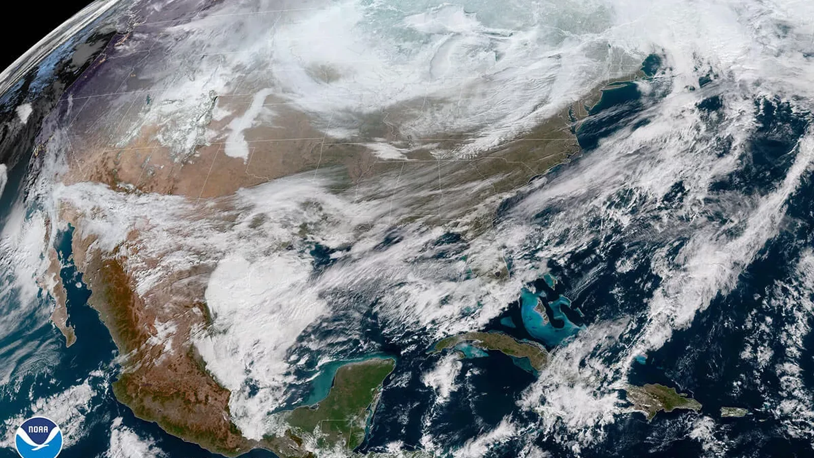
The satellite photograph accompanying this article is an archive NOAA GOES-East image from 30 January 2019. It illustrates a past cold-air outbreak over the United States. It does not show the November 2026 UK forecast or a current stratospheric wind analysis. NOAA’s image explanation provides the original context.
Frequently asked questions
Will the weakening vortex bring snow to London?
The vortex signal alone cannot answer that. Use London’s local forecast as the relevant dates approach. Snowfall requires suitable conditions in the lower atmosphere as well as precipitation.
Is a polar vortex split the same as a named winter storm?
No. A vortex split describes the large circulation aloft. A named storm is a separate weather system. A headline linking the two still needs evidence about the actual surface conditions.
Does warming above the Arctic mean a warmer UK?
No. The word refers to temperatures in the stratosphere. Its possible influence on lower-level circulation can favour colder conditions in some regions, but the UK response varies.
Should I make plans using a whole-winter snow prediction?
Use a seasonal outlook for broad context. For an individual journey or event, rely on forecasts and operator information relevant to the location and date.
For more explainers and practical guides, browse Horus Valley in English.
Sources
You may also like
 Science & Technology
Artemis II Explained: What It Achieved and Why It Didn’t Land on the Moon
What Artemis II achieved, why it did not land on the Moon, what NASA learned from Orion’s heat…
 Science & Technology
Can Capella-2 See Through Walls? What SAR Satellites Really Show
Capella-2 cannot see into homes. Learn why Tokyo’s radar image looked transparent, what SAR really detects, the meaning…
 Home & Living
Why Do Ceiling Fans Collect Dust Even When They Are Spinning?
A physics-backed explanation of dust buildup on spinning ceiling fan blades, plus safe cleaning methods and practical ways…