
The Lost Ahramat Nile Branch: How Did Ancient Egyptians Transport Stone to the Pyramids?
The lost Ahramat Branch of the Nile may help explain how ancient Egyptians reached pyramid sites. Explore the original maps, evidence for a buried river, and what the findings do—and do not—prove about transporting stone.
Contents
- What Was the Ahramat Branch, and Where Did It Run?
- Why Does the Pyramid Landscape Look Different When We Put the River Back?
- How Can Scientists Find a River That Has Vanished From the Surface?
- Remote Sensing Helps Identify Where to Look
- Geophysical Surveys and Sediment Cores Test the Interpretation
- Were Pyramid Stones Transported Along This Nile Branch?
- Moving Stone, Lifting Blocks, and Building a Pyramid Are Different Problems
- What Do Valley Temples and Pyramid Causeways Have to Do With Water?
- Why Don’t the Study’s Numbers Describe Every Pyramid Site Equally?
- How Could Such a Large River Branch Disappear?
- Was the Ahramat Branch Discovered in 2026?
- How to Read the Two Original Research Maps in This Article
- What Could Future Research Add?
- What We Actually Know About the Lost Ahramat Branch
- Primary Sources and Map Licensing
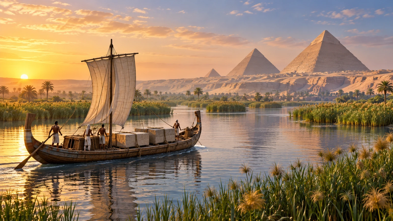
The lost Ahramat Branch of the Nile is the name researchers gave to an ancient channel whose traces they identified between Lisht and Giza in Egypt. A study published in 2024 supports the possibility that this waterway helped workers and building materials reach pyramid sites. Its importance is that it restores water to a landscape we now tend to see as desert—and offers a geographical explanation for why so many monuments stand along one relatively narrow corridor.
But identifying a possible transport route does not, by itself, explain every aspect of pyramid construction. Between delivering a stone to a riverbank and placing it in its final position lay several distinct tasks. This article therefore separates evidence that a channel existed, the case for its use in transport, and the engineering questions that require other evidence. The primary study was published on May 16, 2024; it is not a new discovery announced in October 2026.
What Was the Ahramat Branch, and Where Did It Run?
Eman Ghoneim and her colleagues reported evidence for sections of an ancient river branch at the foot of the Western Desert Plateau in Communications Earth & Environment. The proposed course extends about 64 kilometers (40 miles) and runs beside the locations of 31 pyramids examined in the paper. An estimated channel width of 200–700 meters (roughly 650–2,300 feet) points to a substantial waterway rather than a narrow irrigation ditch.
The name Ahramat comes from the Arabic word for “pyramids.” It is a modern name proposed by the researchers for the channel they investigated. The paper does not present it as an ancient Egyptian name recovered from an inscription. It is worth distinguishing a convenient contemporary geographical label from the names that people may have used in antiquity.
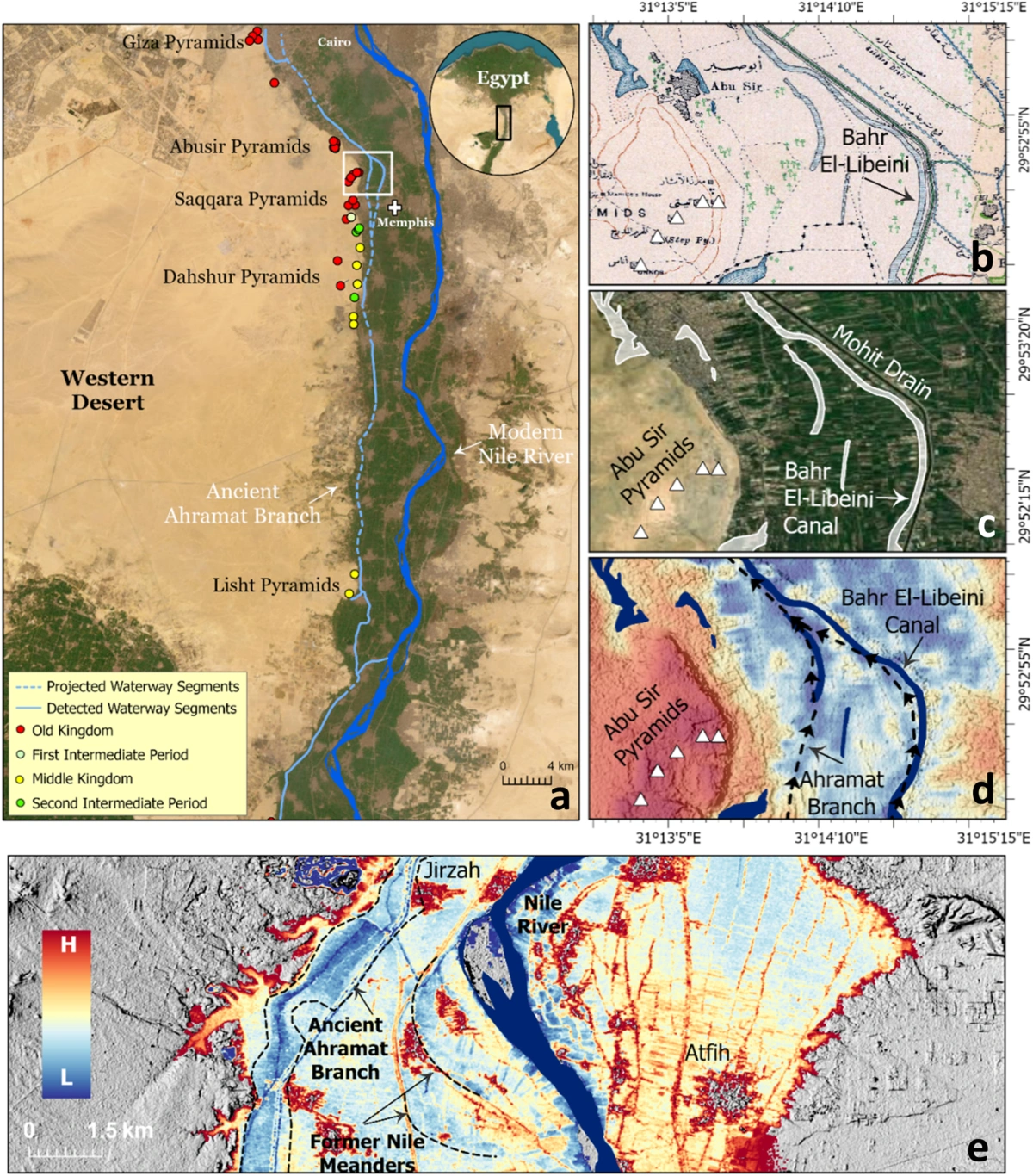
Start reading the map by locating the pyramids and the present-day Nile, then trace the former course reconstructed by the team. In panel a, the key distinguishes detected waterway segments, drawn as solid lines, from projected segments, drawn as dashed lines; the colors of the dots differentiate historical periods. That distinction matters: the map does not claim equally direct evidence for every part of the line. Nor is it a photograph of a river that is still flowing underground.
Why Does the Pyramid Landscape Look Different When We Put the River Back?
Standing on a desert plateau today, it is easy to assume the view has remained essentially unchanged for thousands of years. But the decision to build a massive monument depended on the access routes, resources, and environment available at the time—not simply on how the area looks after centuries of change.
The University of North Carolina Wilmington explains that the findings may help account for the concentration of pyramid fields along this corridor, near the ancient capital of Memphis. The university also notes that some pyramid causeways extended toward the banks of the proposed channel, supporting the idea that waterways mattered for access to the complexes. This is evidence about a monument’s location within a wider transport network.
For an analogy, imagine finding an old railway station after the tracks that once served it have disappeared. Its location might seem puzzling on a modern road map; restoring the former rail line would help explain why it was built there. The comparison helps illustrate landscape change—it is not extra evidence that any particular section of the Ahramat Branch was used.
How Can Scientists Find a River That Has Vanished From the Surface?
The research team combined radar and terrain data with geophysical surveys and sediment samples. The strength of the approach lies in how these techniques test different parts of the same explanation: the shape of a possible route, the structure beneath the surface, and the kinds of material deposited there. The argument does not rest on a single colorful satellite image.
Remote Sensing Helps Identify Where to Look
Remote-sensing data may reveal patterns that are hard to notice in ordinary photographs—or while walking over terrain that appears flat. Yet any long, channel-like feature needs interpretation: is it evidence of an old river, a different landform, or a more recent structure? The case becomes stronger when mapped patterns can be checked against observations on the ground.
Geophysical Surveys and Sediment Cores Test the Interpretation
Researchers can examine the properties of subsurface layers and compare sediment deposits with what they would expect from a river environment. It is important to distinguish a location directly sampled or measured from a larger area inferred by connecting observations. Supporting cores make a reconstruction more robust; they do not mean that every meter of the mapped channel has been excavated.
| Evidence type | Question it helps answer | What it cannot establish by itself |
|---|---|---|
| Satellite and terrain data | Where might a former river course have left a trace? | The dates and details of its use |
| Geophysical surveys | Does the subsurface structure fit a buried channel? | Which particular human activities occurred there |
| Sediment cores | Are the deposits consistent with a river environment? | Whether a specific shipment of stone passed by |
| Valley temples and causeways | Do architectural locations make sense with water access? | The design or operation of every landing place |
Were Pyramid Stones Transported Along This Nile Branch?
The paper proposes that the channel acted as a transport route, drawing on its proximity to pyramid complexes and the way some causeways extend toward its reconstructed banks. A press release about the study frames this relationship as a possible explanation for pyramid locations and accessibility. That is a much more specific claim than saying “the mystery of the pyramids is solved,” which bundles several unrelated questions into a single headline.
Three levels of evidence should remain separate: establishing that a waterway existed; arguing that people probably used it for transport; and proving that a particular load traveled from a particular quarry to a particular pyramid along a particular route. The third claim demands further detailed evidence. It does not automatically follow from the first two.
As an explanation of the landscape, the waterway changes how we think about distance. A site that appears farther away overland could have been easier to reach if it was connected to suitable water transport. But estimates of transport costs, workforce numbers, or journey times would require information about boats, cargo capacities, seasons, and unloading methods. Such figures are not presented here as findings from the study.
Moving Stone, Lifting Blocks, and Building a Pyramid Are Different Problems
A simplified work sequence might be: quarrying the material, transporting it, unloading it, moving it across the construction site, and finally lifting and positioning it. This is an analytical breakdown of the challenge—not a documented step-by-step reconstruction of any particular pharaonic building project.
| Stage | Possible relevance of the waterway | Further evidence needed |
|---|---|---|
| Reaching the building area | Offers a plausible route for people and cargo | A chronological and geographical connection between channel and site |
| Unloading at the bank | Helps explain why a landing point mattered | Evidence of facilities, equipment, and site organization |
| Moving a block overland | May shorten part of the land transport route | Evidence for hauling methods and ground routes |
| Lifting and fitting blocks | Does not identify the lifting mechanism | Construction-specific archaeological and engineering evidence |
A map of the river branch therefore cannot establish that a specific ramp system was used or rule out every alternative lifting method. Discovering an important route to a building site does not replace evidence from the construction site itself. Likewise, locating an ancient road would not, on its own, reveal precisely how the buildings beside it were erected.
What Do Valley Temples and Pyramid Causeways Have to Do With Water?
The study identifies places where pyramid causeways appear to end near the reconstructed riverbank and discusses whether valley temples served as access points linked to the waterway. In this context, the spatial relationship between temple, causeway, and pyramid helps researchers interpret the wider landscape.
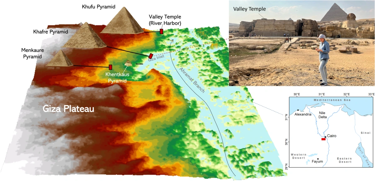
The Giza figure shows the researchers’ interpretation of a former water inlet and its relationship with nearby pyramid complexes. Compare the directions of the causeways with the proposed channel location, but do not treat every line in the figure as an excavated canal visible today. Some elements are surviving archaeological features; others are reconstructions based on the data.
“Possible access point” is generally a more careful description than imagining a fully equipped modern dock. Establishing a broad function does not establish the exact shape, capacity, or level of traffic of every associated structure.
Why Don’t the Study’s Numbers Describe Every Pyramid Site Equally?
The 64-kilometer figure describes the proposed extent of the branch, while the count of 31 pyramids refers to the monuments examined in the research area. These figures do not mean all the pyramids were built at once—or that the channel served every site in precisely the same way throughout its history.
A channel’s width at one cross-section is also different from the thickness of sediment deposits or the depth of an ancient riverbed measured elsewhere. If news reports quote different numbers, first check what each number actually measures, where it was measured, and which period it refers to. Combining observations from different sites into one set of “river specifications” can create a misleading impression.
A historical reconstruction is more like combining multiple moments across time than taking one instantaneous photograph. Evidence that a branch was active in one period does not mean it kept the same shape and water level for every century that followed. That is why dating the sediments—and comparing environmental findings with monument chronology—is essential.
How Could Such a Large River Branch Disappear?
The team discusses channel migration, sediment accumulation, and encroaching sand as parts of long-term environmental change. The university statement suggests that greater sand deposition may have been connected to an arid phase beginning about 4,200 years ago. This is a proposed relationship, not a date for one dramatic event or the precise day when the entire branch ran dry.
One part of a river network can become less active and gradually fill with sediment while land use above it changes. The evidence a geomorphologist studies can remain buried in layers long after the water disappears from view. Searching for an ancient river course is therefore not the same as looking for a currently flowing underground river.
It would also be mistaken to turn the approximate date of a climatic episode into a fixed deadline for all navigation in the region. Local channel closures and changing patterns of use have to be traced geographically and chronologically—not assigned a single date across the entire map.
Was the Ahramat Branch Discovered in 2026?
No. The peer-reviewed study was published on May 16, 2024. New media coverage or a resurfacing of the maps does not change when the original findings were reported. That distinction helps readers recognize whether they are seeing genuinely new evidence or a later explanation of existing research.
Before accepting a headline claiming that a “new discovery finally proves how the pyramids were built,” look for the paper’s title, publication date, and actual scope. The new item may concern another analysis or a different site—or it may simply recycle the same map. This article explains the published study; it does not claim that Horus Valley has conducted an independent archaeological survey.
How to Read the Two Original Research Maps in This Article
- Read the figure legend before interpreting colors and lines: they represent different kinds of information and are not all features visible to the naked eye.
- Check the scale and north arrow before comparing distances between monuments.
- Distinguish the present Nile course from the reconstructed ancient branch.
- Verify place names and avoid applying findings from one short stretch to the entire channel.
- Remember that the maps combine archaeological locations, modern measurements, and interpretations of the ancient landscape.
Both figures have been included from the research paper so you can follow these steps while viewing their original labels and scales. The featured image, by contrast, is a conceptual reconstruction; it is neither an image of a boat recovered from this branch nor an accurate map of its ancient banks.
What Could Future Research Add?
The map helps identify places worth investigating with further fieldwork and appropriate dating techniques. It also raises testable questions: How did subsidiary channels change over time? Which structures stood beside active banks in particular periods? Can more evidence of access points or facilities supporting river transport be found?
These are research questions—not a list of findings already established. The value of the 2024 work is partly that it turns a vague question about the “secret of the pyramids” into geographical and chronological problems researchers can test. Later studies might refine or revise details of the reconstruction without rendering every earlier result meaningless.
For related context on how the Nile shaped ancient Egyptian understandings of time and the environment, see our Arabic-language article on Sirius, the Nile flood, and the ancient Egyptian calendar. It is a companion topic, not independent evidence for the Ahramat Branch’s route.
What We Actually Know About the Lost Ahramat Branch
The study supports the existence of an ancient river corridor near a chain of pyramid sites and offers an important explanation of how people may have reached them by water. It does not reduce stone extraction, transportation, lifting, and placement to a single technique. The most useful reading restores the environmental setting in which the builders worked while keeping the limits of each type of evidence clear.
Instead of imagining the pyramids as isolated stone islands in an unchanging desert, the maps invite us to picture a connected system of water, banks, paths, and buildings. That shift in perspective is the key contribution: seeing pyramid locations as parts of a working transport landscape—and then asking what the evidence can really establish.
Primary Sources and Map Licensing
- Ghoneim et al. (2024), the original peer-reviewed study in Communications Earth & Environment.
- University of North Carolina Wilmington: the research team’s university announcement.
- Springer Nature press release on the study and its archaeological significance.
Both maps reproduce Figures 1 and 7 from Ghoneim et al. (2024), under the Creative Commons Attribution 4.0 International license (CC BY 4.0). Only their file format and display size were adjusted; the original labels and mapped routes were not changed. Sources last reviewed: October 27, 2026.
You may also like
 Science
Why Can’t We Remember Being Babies? What Memory Research Shows
Why our first years are hard to recall, what infant brain scans reveal, and why forming a memory…
 Science
Can Octopus Arms Think for Themselves? What the Science Shows
How octopus arms process information, what segmented nerve cords reveal, and why local control does not prove nine…
 Science
How Did a Human Brain Turn Into Glass at Herculaneum?
How did a Roman victim’s brain become glass-like? Explore the Herculaneum evidence, the 2025 thermal study, original microscopy…