
Buto Discovery: How Radar and Excavation Revealed a Buried Saite Building
At ancient Buto in Egypt, satellite radar, electrical surveys and excavation reveal a buried Saite-era mudbrick structure. See the real images, dimensions and remaining mysteries.
Contents
- Where is Buto, and why are its buried remains difficult to investigate?
- From satellite radar to excavated walls: how did the investigation work?
- 1. Identify an unusual radar signal
- 2. Measure the electrical properties of the ground
- 3. Test the interpretation through excavation
- How large is the buried building? The measurements refer to different things
- What objects were found alongside the walls?
- Why does the sand layer beneath the structure matter?
- What is confirmed, and what remains uncertain?
- Frequently asked questions
- Was the ancient city of Buto discovered for the first time?
- Is this the same discovery as the Buto astronomical observatory?
- Can visitors see all the building's rooms today?
- Sources, image credits, and further reading
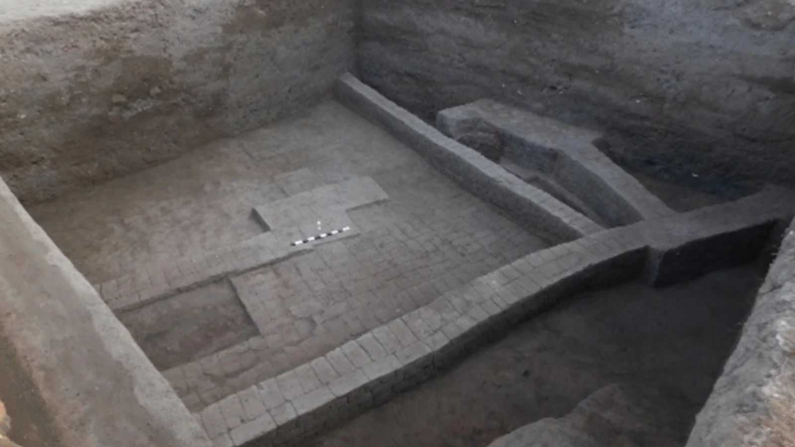
Researchers investigating Buto (Tell el-Fara’in) in Egypt’s Kafr El-Sheikh Governorate have identified the remains of a buried mudbrick structure probably associated with the Saite period, roughly 2,600 years ago. The study combines Sentinel-1 satellite radar data, electrical resistivity tomography (ERT), and targeted excavation that exposed walls and archaeological objects. Its purpose remains uncertain: the building may have been a secondary shrine, a priestly residence, a religious service complex, or a structure with a funerary function.
The peer-reviewed study appeared in Acta Geophysica on March 10, 2026 and attracted renewed media attention in November. It would therefore be misleading to describe this as a first-ever field announcement in November 2026. Satellite analysis helped select promising areas, but measurements and excavations on the ground supplied the evidence for the buried architecture.
Where is Buto, and why are its buried remains difficult to investigate?
Buto, also known as Tell el-Fara’in, lies in the northwestern Nile Delta. It is a long-studied archaeological site with occupation layers from multiple historical periods. The research concentrated on a settlement mound known as Kom C, where buildings and deposits from successive phases complicate the interpretation of what lies beneath the surface.
The Egyptian Ministry of Tourism and Antiquities describes Buto’s historical importance in its Kafr El-Sheikh Museum overview. Museum material from Buto includes objects associated with its cemetery and temple area. That context makes buried architecture at the site significant, but it does not by itself establish the function of this particular structure.
Groundwater, fine Nile Delta sediments, and centuries of construction and disturbance make deeper archaeological levels difficult to examine. A promising shape on an image may not correspond directly to a single ancient building. Researchers therefore need several independent methods before choosing where to excavate.
From satellite radar to excavated walls: how did the investigation work?
1. Identify an unusual radar signal
The researchers examined Sentinel-1 radar data acquired on May 5, 2018, and detected an unusual pattern in the study area. Scientists call such a contrast an anomaly: it indicates that an area differs from its surroundings in the measured data. An anomaly alone does not establish that a tomb, temple, or building is present.
As the European Space Agency explains in its overview of Sentinel-1, radar records reflected microwave signals affected by factors such as surface roughness and moisture. It is not a conventional camera image. Radar operation through clouds or at night should not be confused with the ability to photograph buried rooms directly at any depth, especially in wet clay.
2. Measure the electrical properties of the ground
Next, the team used electrical resistivity tomography, usually shortened to ERT. Electrodes placed on the ground introduce electrical current and measure voltage differences. Computational analysis then estimates how subsurface resistivity varies. Contrasting resistivity patterns can suggest walls, fill, or sediments, but archaeological interpretation is still required.
The survey comprised 15 parallel measurement profiles arranged in two areas. The researchers compared quasi-3D images assembled from separately inverted two-dimensional sections with models produced using full 3D inversion. Here, inversion means finding a plausible subsurface model to explain the measurements—not taking a photograph underground.
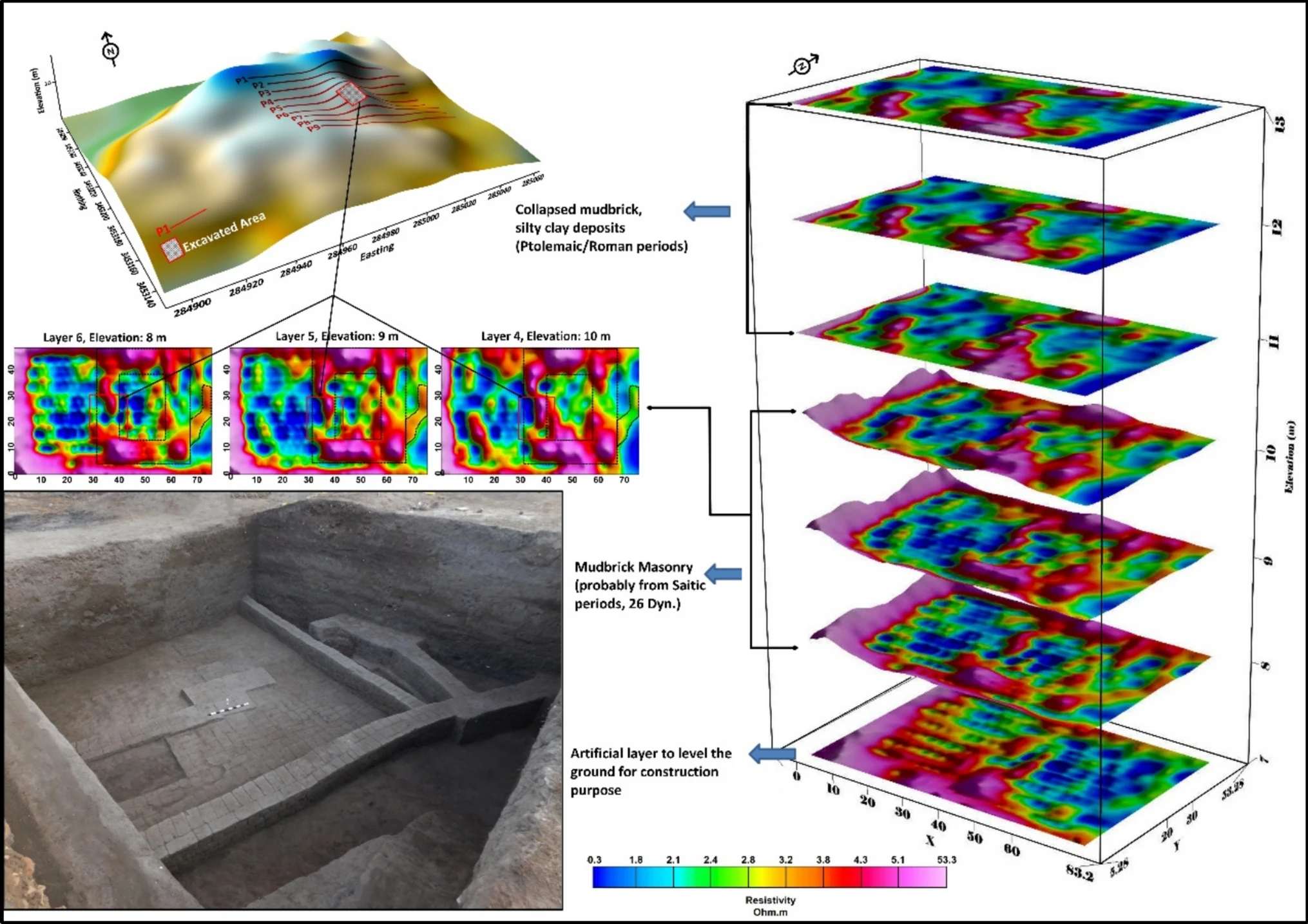
The illustration compares resistivity modeling with excavation evidence. The colors encode modeled resistivity values; they are not the real colors of buried walls or a map of precious metals. Credit: Abouarab et al., Figure 13, Acta Geophysica (2026), licensed under CC BY 4.0.
3. Test the interpretation through excavation
Archaeologists opened a 10 × 10 m test area divided into four squares. They exposed mudbrick walls and recovered archaeological materials, providing physical support for interpreting the measured anomalies as architecture. An apparently regular shape in a digital model cannot independently establish the material, date, or purpose of a structure.
How large is the buried building? The measurements refer to different things
Reports can confuse the overall satellite-radar anomaly with the building estimated from ground measurements or with the much smaller excavated area. The study distinguishes these measurements:
| Measurement | What it describes | What it does not prove |
|---|---|---|
| About 128 × 62 m | Extent of the oval-looking feature in satellite radar analysis | Not the definitive plan of a fully uncovered building |
| About 20 × 25 m | Approximate rectangular structure interpreted from ground resistivity models | An interpretation supported by partial excavation, not a completely exposed floor plan |
| 10 × 10 m | Test excavation area divided into four squares | Not the full footprint of the suspected building |
| About 3–6 m | General depth range of the main Saite-period subsurface anomaly | Depths and exposures vary across profiles and excavation squares |
| About 6–7 m | Depth range of the high-resistivity sandy foundation layer | Its artificial origin and precise engineering function are interpreted from combined evidence |
A rectangle measuring 20 by 25 meters would cover approximately 500 square meters. That is a calculation based on the modeled dimensions, not a measured area of excavated rooms. The researchers also explain that the satellite’s viewing direction affects the appearance of the radar feature; its oval outline is not proof that the ancient building itself was oval.
What objects were found alongside the walls?
The study describes amulets and religious objects, including wedjat-eye charms, representations of Isis, Horus, Taweret, Wadjet, and Bes, a small offering basin, and a scarab bearing the name of Thutmose III. Such material makes ritual or funerary activity plausible. It cannot by itself distinguish a shrine from a priestly dwelling or another associated building.
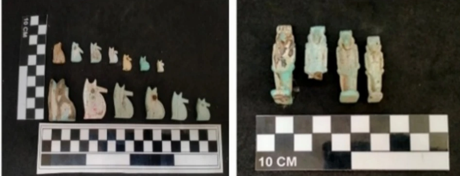
A royal name on an amulet does not automatically date every wall around it to that ruler’s reign. Objects may remain in circulation, be reused, or enter a deposit long after they were made. Archaeologists examine the findspot, the layer, the walls, and associated material together. For a fuller explanation, see our guide to how archaeologists date artifacts and the contexts in which they are found.
Why does the sand layer beneath the structure matter?
Electrical resistivity readings and earlier borehole evidence point to a sandy layer beneath the architectural remains. The researchers interpret it as material deliberately introduced to level or reinforce the foundation. If correct, it suggests that Saite builders adapted the unstable ground before constructing the walls.
However, identifying sand, interpreting it as intentionally placed, and quantifying its long-term structural performance are different claims. This study does not independently measure how much settlement or moisture damage the layer prevented over 2,600 years. It is also important to distinguish a proposed man-made building foundation from much older natural sandy deposits elsewhere in the Delta’s stratigraphy.
What is confirmed, and what remains uncertain?
- Confirmed by excavation: mudbrick walls and archaeological objects were recovered within the test area.
- Supported by multiple lines of evidence: a Saite-period interpretation of the structure and the identification of architectural remains within some resistivity anomalies.
- Still unresolved: the building’s exact function, complete boundaries, relationship to neighboring structures, and possible changes in use over time.
The survey also has technical limitations: the spacing and orientation of the measurement profiles affect how sharply specific walls can be defined. Three-dimensional processing improves interpretation but cannot create detail that the measurements never captured. Wider surveys and further excavations would help test the competing explanations.
Frequently asked questions
Was the ancient city of Buto discovered for the first time?
No. Buto is a well-known archaeological site that has been studied for decades. The research concerns buried remains within an already identified settlement, not the discovery of an entirely unknown Egyptian city.
Is this the same discovery as the Buto astronomical observatory?
They should not be treated as the same announcement. The Egyptian Ministry of Tourism and Antiquities separately reported an astronomical observatory at Buto. The Acta Geophysica study examines Kom C and a structure whose precise purpose remains undetermined. The shared site and broadly similar historical period do not demonstrate that these reports concern the same building.
Can visitors see all the building’s rooms today?
The study does not document a completely excavated building with a confirmed room-by-room plan or visitor access. Its images show a limited excavation and geophysical models. Colored areas in those models should not be mistaken for uncovered rooms that can be toured.
Sources, image credits, and further reading
- Abouarab et al., Acta Geophysica, volume 74, article 112, published March 10, 2026. Primary source for methodology, measurements, excavations, interpretation, and figures.
- European Space Agency: Sentinel-1 uses and radar observations. Background on the instrument and its applications.
- Egyptian Ministry of Tourism and Antiquities: Kafr El-Sheikh Museum. Historical context for Buto.
- Egyptian Ministry of Tourism and Antiquities: Buto astronomical observatory announcement. A separate discovery, included to prevent conflation.
- Photographs and research illustrations are adapted from Figures 13 and 18 of Abouarab et al. (2026), under Creative Commons Attribution 4.0. Selected images were cropped and resized and converted to WebP; no archaeological features were invented.
Sources and factual information reviewed: November 7, 2026.
You may also like
 History & Civilizations
Grey Aliens: Where Did the Big-Eyed Greys Story Begin?
A documented investigation into the origin of Grey alien imagery, the Hill encounter and the difference between historical…
 History & Civilizations
Ubaid Lizard Figurines: What the Reptilian Heads Really Show
Examine real Ubaid figurines with British Museum and Penn Museum records, original photos, a nursing mother’s missing head,…
 History & Civilizations
How Do Archaeologists Date Ancient Artifacts? Radiocarbon, Layers, Pottery and the Limits of Scientific Dating
How do archaeologists date ancient artifacts? Compare carbon-14, stratigraphy, tree rings and pottery dating with practical examples and…