
23 Ancient Ship Carvings Revealed by Laser Scans in Cyprus: What the Evidence Really Shows
An evidence-based guide to the 23 additional ship carving candidates found by laser scanning at Kition, Cyprus, with original study links and interpretation limits.
Contents
- Where were the ancient ship drawings found?
- What was new: 19 earlier ships, 23 additional candidates and a revised catalogue
- How did laser scanning uncover marks invisible to the naked eye?
- Why depth and angle are better than simply brightening a photograph
- What kinds of ancient vessels are represented?
- Were these warships or trading ships?
- Did people carve the ships all at once?
- Why carve ships on a temple wall rather than on paper or wood?
- How to inspect the real archaeological evidence yourself
- A practical five-question checklist for any surprising archaeological scan
- Can a laser scan preserve an archaeological site?
- What this discovery does not prove
- Research sources and image credits
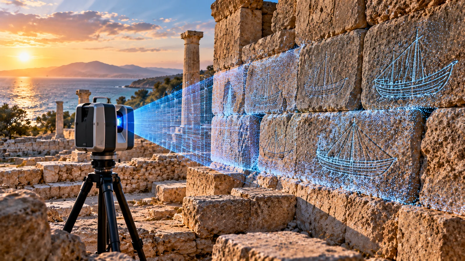
Laser scanning at the ancient city of Kition in Cyprus has revealed 23 additional possible ship carvings on the stone façade of a Bronze Age temple. The discovery adds to a body of maritime graffiti first documented decades ago, but the number needs care: the 2026 scientific study rates nine of the 23 new candidates as high-confidence, six as medium-confidence and eight as low-confidence. Some could be damage or marks that do not depict boats. More remarkable than a dramatic headline is what the carvings may reveal: seafaring imagery remained important to people in this port community across the transition from the Late Bronze Age into the Early Iron Age.
The carvings were documented during 2024 fieldwork, preliminary digital-heritage findings appeared in a 2025 peer-reviewed conference paper, and the detailed reassessment by Graham C. Braun, Caroline Barnes and Tzveta V. Manolova was published online in the International Journal of Nautical Archaeology on 18 August 2026. The University of Cincinnati highlighted the work on 8 October 2026. Those different dates should not be collapsed into one claim of an October archaeological discovery. Original 2026 research · Open-access 2025 research · University announcement.
The research is also a lesson in how technology changes archaeological interpretation without making uncertainties disappear. Below, we trace where the marks were found, how the scanning works, how researchers distinguished ships from damage, and what the drawings can—and cannot—tell us about ancient Mediterranean history.
Where were the ancient ship drawings found?
The site is Kition Kathari, an archaeological area within present-day Larnaca, on the southern coast of Cyprus. In the Late Bronze Age, Kition belonged to a wider Eastern Mediterranean network linking Cyprus with coastal communities in the Levant and the Aegean. Its position mattered because sea routes carried people, objects, technologies and ideas across the region. That is a historical context, not proof that every vessel carved on the temple wall personally sailed a specific route.
Most of the ship graffiti are incised into blocks along the southern façade of the monumental building known as Temple 1. Two more ship images are associated with an altar in Temple 4. Archaeologists use the word graffiti here in a technical sense: informal marks cut into a surface that was not originally designed as a dedicated image panel. It does not mean modern spray paint or an act of vandalism.
The wall was already known to archaeologists working in the twentieth century. The great surprise was not finding an untouched temple: it was discovering that the familiar, weathered surfaces preserved far more information than standard photography and direct observation had revealed. See the original photograph of the Temple 1 façade in Figure 1 of the open-access paper.
What was new: 19 earlier ships, 23 additional candidates and a revised catalogue
A study published in the mid-1980s documented 19 ship graffiti on the Temple 1 wall. Later specialists knew that erosion made some ancient incisions extraordinarily hard to read. Digital recording in 2024 brought additional possible images to light and corrected the appearance of some previously published sketches.
The 2025 preliminary paper described 21 previously undetected marks on the main orthostat blocks, plus two on a later repair block—a total of 23 additional candidates. Its preliminary arithmetic described 42 on the main wall when combined with the earlier 19. The detailed 2026 article reassessed individual identifications and describes 43 ship graffiti in its studied and illustrated corpus across the temple features. Because the catalogue involves reassessment, two altar carvings and earlier marks later judged to be damage, do not add the numbers from separate publications as if every mark were a unique confirmed ship.
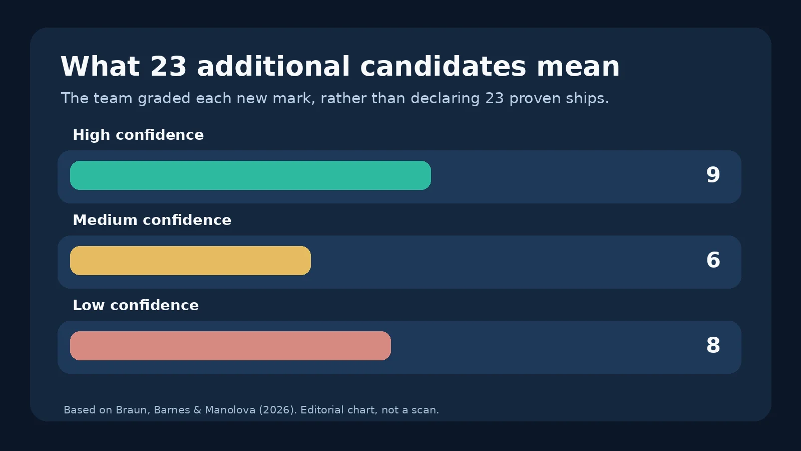
A critical distinction is that the researchers did not simply declare all 23 extra marks to be boats. The 2026 study classified the additional candidates on Temple 1 into three confidence groups:
| Evidence category | Candidates | What it means |
|---|---|---|
| Level 3 — high confidence | 9 | Preserved shapes and incisions make a ship interpretation convincing |
| Level 2 — medium confidence | 6 | Probable human-made lines with some vessel-like characteristics, but uncertainty remains |
| Level 1 — low confidence | 8 | Ambiguous marks; some may be damage or an incomplete image |
This classification helps readers separate a research inventory from 23 completely proven ship portraits. It also makes the work more useful: a future scholar can reconsider a Level 1 mark without having to pretend the original team expressed absolute certainty. The research identifies some older candidate marks as likely damage rather than graffiti, demonstrating that digital methods can both add and reject identifications.
How did laser scanning uncover marks invisible to the naked eye?
The team used terrestrial laser scanning, including a FARO Focus3D X330 instrument. The scanner measures an enormous number of points across a stone surface to create a three-dimensional representation called a point cloud. Rather than relying only on the color differences visible in a photograph, researchers can then evaluate tiny differences in the geometry of the wall.
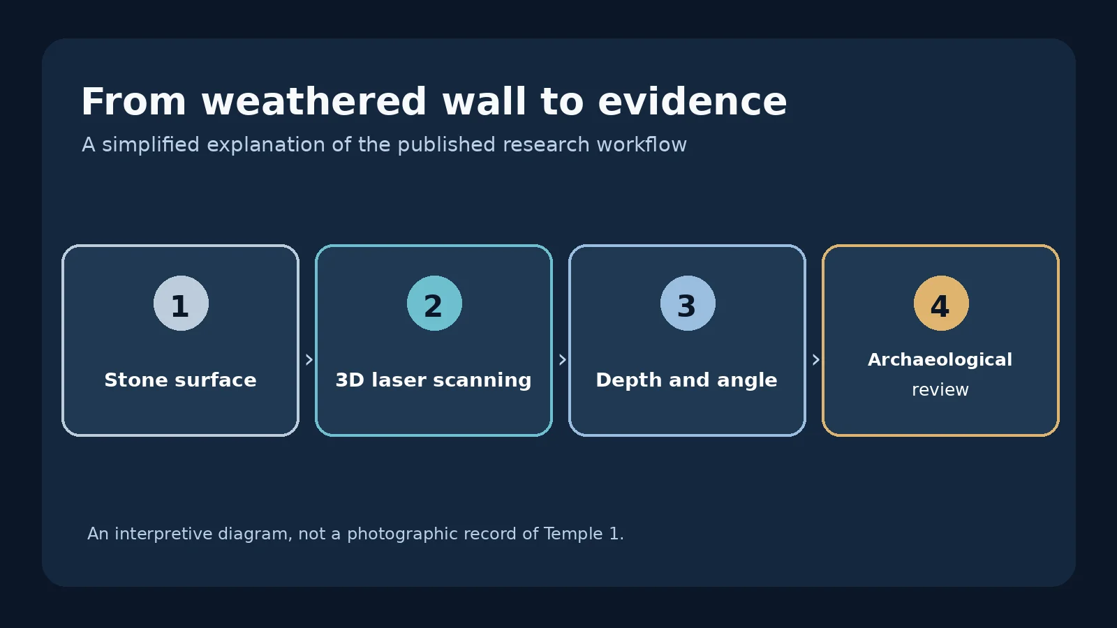
The workflow involved several distinguishable stages. First, the survey recorded the Temple 1 façade from carefully selected scanning positions, without cutting or touching the stone. Second, dedicated software processed the point cloud into a model of the wall. Third, specialists used tools such as Distance to Plane (DtP) to show relative depth and Angle to Plane (AtP) to reveal how small incisions change orientation across the stone surface. Finally, the team compared suspicious lines with photographs, archaeological context and known ship forms before drawing and cataloguing each candidate.
The method is not a machine that automatically knows what a ship looks like. A dark line in a heatmap may represent a cut, a crack, a modern scrape or a natural defect. An archaeologist still has to decide which explanation is best supported. The 2025 CC BY 4.0 paper includes a real scan visualization in Figure 4, page 3.
Why depth and angle are better than simply brightening a photograph
Imagine trying to read very faint pencil lines on rough paper. Increasing brightness does not necessarily distinguish a pencil stroke from a crease in the paper itself. A three-dimensional scan adds another kind of evidence: it tells you how the surface rises, falls and changes slope. At Kition, the angular direction and depth of cuts helped researchers distinguish some intentional engravings from stone damage.
This does not mean the laser restored missing limestone, decoded the carvers’ intentions or photographed ships that were physically present. The images are carved depictions. The scanner measures the surviving stone, while any reconstructed lines remain an interpretation of incomplete evidence.
What kinds of ancient vessels are represented?
The researchers arranged much of the corpus into six broad groups based on combinations of ship shapes, rather than assuming that a single curved hull identifies an exact ancient model. The assemblage includes parallels to Levantine merchantmen, galleys and sailing traditions of the Aegean, alongside locally distinctive Cypriot characteristics. Some drawings include hints of a mast, rigging, upright ends or other features; many are only a few strokes long.
A useful way to read the images is to separate three levels of interpretation: visible geometry (for example, a curved line and an upright stroke), proposed vessel class (a galley or a cargo ship), and historical conclusion (which communities used such imagery). Evidence becomes less direct as you move down that chain. A mast-like line does not identify a crew, a flag or a named port of departure.
The collection is particularly valuable because several ship-building traditions appear at one coastal sacred complex. This fits Cyprus’s wider maritime connections. Yet it would be an overstatement to conclude that Kition’s residents built every illustrated vessel or that all the carvings are eyewitness records of particular voyages. Representations can be copied, stylized or remembered long after a ship is seen.
Were these warships or trading ships?
Some carvings resemble slender, galley-like vessels; others have broader cargo-ship characteristics. A ship’s shape can suggest a likely function, but the sketches are not technical blueprints. An ancient galley was not automatically engaged in warfare every time it sailed, and a merchantman could carry passengers or a mixture of goods. The researchers’ typological comparisons are more informative than labeling every long hull a battleship.
One especially interesting group has characteristics of a hybrid galley known from comparisons around the Carmel coast and Akko. The authors treat these as meaningful parallels in ship imagery and possibly maritime practices, not as direct evidence identifying the individual artists’ hometowns.
Did people carve the ships all at once?
Probably not. Earlier interpretations had tended to place the entire group in the Late Bronze Age. The new work combines the positions of the carvings on the masonry, phases of architectural repair and comparisons to other maritime images. A key observation is that a repair block near Temple 1 also contains ship graffiti. If this stone was installed substantially later than the original wall, its carved image cannot simply be assumed to date to the wall’s earliest construction.
The authors argue that carving may have continued from the Late Bronze Age into the Early Iron Age, potentially for as long as approximately 300 years. This is an archaeological interpretation supported by several kinds of evidence, not a date stamped beside each ship. The carvings were not necessarily produced at regular intervals, and the exact day, year and hand of each artist remain unknown.
The broader historical significance lies in continuity through change. Eastern Mediterranean societies underwent major transformations at the end of the Bronze Age, but evidence of repeated maritime imagery at Kition makes it harder to describe the transition as an abrupt disappearance of all local traditions. A continuous image-making practice is not proof that trade volumes, political institutions or living standards remained unchanged.
Why carve ships on a temple wall rather than on paper or wood?
The simple answer is that we do not know the carvers’ exact purpose. A temple setting invites hypotheses about protection, offerings, religious practices, identity, memory and seafaring experience. All are worth discussing; none should be announced as proven solely because a drawing appears near a sacred area.
Their location is nevertheless suggestive. The imagery appears on prominent, valued stone in a public-looking architectural setting rather than on an isolated discarded object. The repetition across different periods could indicate that ships had an enduring symbolic role for groups using the complex. Researchers also consider parallels with ship graffiti on altars elsewhere in the eastern Mediterranean. However, it is uncertain whether an individual carving was devotional, decorative, commemorative or simply the mark of a person familiar with ships.
A particularly responsible reading avoids inventing an ancient ‘captain’ who left a message. The carvings preserve a visual practice; they do not contain readable captions telling us who carved them or why.
How to inspect the real archaeological evidence yourself
The images supporting this story are available through academic and university sources. Some images in the 2026 journal article carry a CC BY-NC-ND publication license or third-party permissions, so do not treat all figures as freely reusable for commercial websites. The 2025 ISPRS preliminary paper is published under CC BY 4.0, with proper attribution still required. This article links directly to photographs and analyses rather than disguising a conceptual illustration as a photograph of the actual carvings.
- Open the 2025 open-access research PDF and examine Figure 1 on the first page. This is a genuine photograph of Temple 1’s southern façade, not an invented ancient harbor scene.
- Turn to Figure 2 on the second page. The comparison of the same orthostat at different dates helps explain why documentation is urgent: the stone has weathered over time.
- Look at Figure 4 on the third page. It is a real processed laser scan; the strong colors describe geometry and processing, not the ancient appearance of the stone.
- Consult the 2026 peer-reviewed study for the confidence classification, repaired block and comparison drawings, including Figures 5–8 where available.
- Read the University of Cincinnati announcement for researchers’ statements and fieldwork photographs with their credits.
When comparing illustrations, look for the number assigned to a graffito, scale bar, damaged portion, scan visualization and confidence label. A dramatically colored interpretation can be more readable than the original stone, but the coloring is not evidence of ancient paint.
A practical five-question checklist for any surprising archaeological scan
This discovery illustrates a wider method readers can use whenever headlines claim AI, lasers or radar uncovered a hidden city, symbol or object.
- What is the instrument measuring? In this case, laser scans measured the surviving stone’s surface geometry; they did not penetrate to a buried wooden ship.
- Was the feature already known? The Kition ship graffiti were known for decades. The contribution is a significantly expanded and corrected catalogue.
- How much confidence do the authors express? Here, only nine of the 23 additional candidates receive the highest confidence rating.
- What is the date of the work? Distinguish 2024 field recording, the 2025 methodological paper and the August 2026 full research publication.
- What would disprove an interpretation? A supposed hull might be a crack or a later scrape; a revised angle-of-cut analysis can weaken a ship identification.
Those questions give this news story a practical benefit beyond the excitement of the headline. They also prevent a common mistake: equating a detailed digital model with certainty about the ancient meaning of every mark.
Can a laser scan preserve an archaeological site?
Digital recording can preserve a high-resolution record, but it cannot physically stop salt, rain, wind, visitor contact or other sources of erosion. The 2025 team stressed that the exposed Temple 1 blocks had deteriorated since excavation. Detailed geometry and photographs provide a reference that future researchers can revisit, compare against fresh scans or use in a virtual model. The project also explored virtual-reality reconstruction to help people experience a wall that is difficult to inspect from the designated visitor route.
There is a distinction between preservation of information and conservation of material. A point cloud may outlast a fragile incision as a digital record, but on-site protection still requires archaeological conservation expertise, public resources and appropriate site management. A visually impressive VR model should also identify which parts reflect measured masonry and which parts are informed reconstruction.
What this discovery does not prove
The site has not yielded 23 excavated ships or a fleet of ancient shipwrecks. It yielded additional possible engraved images of ships on stone. There is no evidence in these sources of lasers recovering lost writing, finding an underwater harbor beneath the wall, or identifying a particular crew. The work does not settle the entire debate over the Bronze Age collapse or show that every image served a single religious purpose.
What the evidence does show is substantial enough: a prominent ancient Cypriot wall preserves a more complex visual record of seafaring than earlier research could capture; its images reflect several Mediterranean ship-building traditions; and the pattern of carving may span generations during a major historical transition. That is the real discovery—and the reason the 3D research matters.
Research sources and image credits
- Braun, Barnes & Manolova (18 August 2026), The Ship Graffiti from Late Bronze Age–Early Iron Age Kition, Cyprus, International Journal of Nautical Archaeology — primary detailed study; images and text require checking their individual usage rights.
- Manolova, Barnes, Braun & Ivanov (2 October 2025), 3D Technologies and Virtual Reality in Archaeology, ISPRS Archives — open-access methods and genuine photographs/scans, © authors, CC BY 4.0.
- University of Cincinnati (8 October 2026), They aimed a laser at a Bronze Age wall and found a fleet — university field report and credited photographs.
- Archaeology Magazine (22 September 2026), Laser Scans Reveal Ship Images on Cyprus Temple Wall — secondary coverage, used for a cross-check rather than as the primary proof.
Editorial image note: The featured visual in this article is a conceptual illustration of digital archaeology, not a photograph, exact reconstruction or scan of the Kition wall. The two explanatory graphics summarize published methods and confidence counts; links above lead to genuine research photographs and instrument outputs. For a related Horus Valley article on maritime archaeology in a very different era, see the 4,700-year-old shipwreck and ancient trade.
You may also like
 History & Archaeology
280 Ice Age Engravings Found in a Spanish Cave: What Archaeologists Discovered
Researchers have documented 280 motifs, including 55 animal engravings, in Spain’s Font Major Cave. Explore the 2019 discovery,…
 Science & Discoveries
Climate Prediction Center Heavy Snow Map: November Outlook
Read NOAA’s November heavy-snow outlook, see the mountain areas at risk, understand the map’s limits, and find local…
 Science & Discoveries
UK November Cold Snap: What the Met Office Forecast Says
What the Met Office forecast says about the UK November cold snap, possible northern wintry showers, frost and…